
ファイル:Bernardo Yorba Adobe.jpg

このプレビューのサイズ: 800 × 591 ピクセル。 その他の解像度: 320 × 236 ピクセル | 640 × 473 ピクセル | 1,024 × 756 ピクセル。
元のファイル (1,024 × 756 ピクセル、ファイルサイズ: 118キロバイト、MIME タイプ: image/jpeg)
ウィキメディア・コモンズのファイルページにある説明を、以下に表示します。
|
| 解説 |
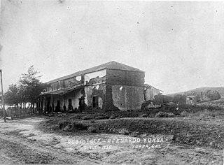
English: Looking northwest towards the Bernardo Yorba adobe house, also called Hacienda Yorba de San Antonio. The south awning and underlying plaster is still intact which is missing in photos taken December of 1919. The roof is not damaged on the east end which an eyewitness account says was present in 1917 which dates the photo before then. The Hacienda was built in 1835 on the north bank of the Santa Ana River on the Rancho Cañón de Santa Ana. Contributed to the Yorba Linda Public Library by the First American Corporation. |
||
| 日付 | 1900年頃 | ||
| 原典 | http://content.cdlib.org/ark:/13030/kt2x0nd101/?layout=metadata&brand=calisphere | ||
| 作者 | 不明 | ||
| 許可 (ファイルの再利用) |
|
| カメラの位置 | | 以下のサービスでこの位置を確認する: オープンストリートマップ |
|---|
ファイルの履歴
過去の版のファイルを表示するには、その版の日時をクリックしてください。
| 日付と時刻 | サムネイル | 寸法 | 利用者 | コメント | |
|---|---|---|---|---|---|
| 現在の版 | 2008年11月6日 (木) 02:00 | | 1,024 × 756 (118キロバイト) | Bluedv | {{Information |Description={{en|1=Looking northwest towards the Bernardo Yorba adobe house, also called Hacienda Yorba de San Antonio. The south awning and underlying plaster is still intact which is missing in photos taken December of 1919. The roof is n |
ファイルの使用状況
以下のページがこのファイルを使用しています:
グローバルなファイル使用状況
以下に挙げる他のウィキがこの画像を使っています:
- ceb.wikipedia.org での使用状況
- en.wikipedia.org での使用状況
- www.wikidata.org での使用状況