
ファイル:Cooks Karte von Neufundland.jpg

このプレビューのサイズ: 615 × 599 ピクセル。 その他の解像度: 246 × 240 ピクセル | 492 × 480 ピクセル | 788 × 768 ピクセル | 1,051 × 1,024 ピクセル | 1,500 × 1,462 ピクセル。
元のファイル (1,500 × 1,462 ピクセル、ファイルサイズ: 521キロバイト、MIME タイプ: image/jpeg)
ウィキメディア・コモンズのファイルページにある説明を、以下に表示します。
|
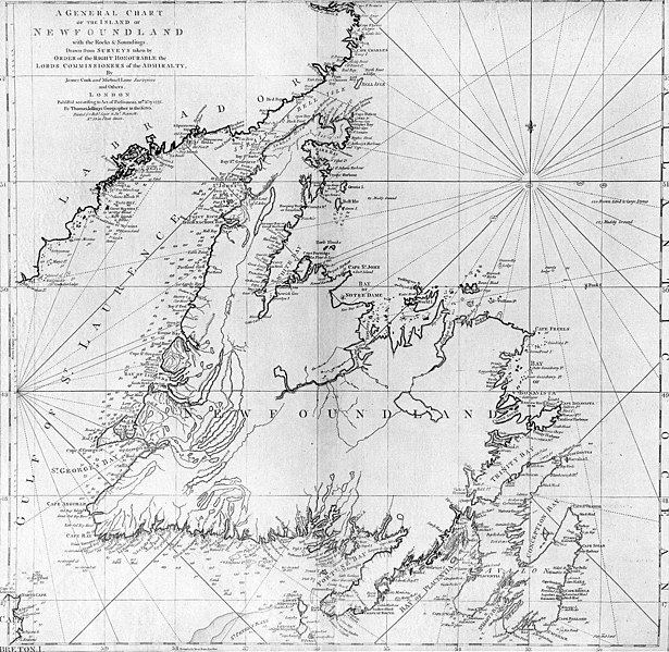
| 解説 | A general chart of the island of Newfoundland. Surveyed by James Cook and Michael Lane, and "publish'd according to Act of Parliament by Thomas Jefferys Geographer to the King, 1775." |
| 日付 | |
| 原典 | originally uploaded to en.wikipedia by Jcmurphy on 23 Apr 2005; copied from "Courtesy of the Centre for Newfoundland Studies, Memorial University of Newfoundland, St. John's, Newfoundland." |
| 作者 | Michael Lane and James Cook |
| 許可 (ファイルの再利用) |
Public domain because of age |
|
この著作物は、著作権の保護期間が著作者の死後100年以下である国・地域においてパブリックドメインの状態にあります。 | |
| このファイルは著作権法の既知の制約(隣接権や関連する権利を含む)から自由であると特定されています。 | |
ファイルの履歴
過去の版のファイルを表示するには、その版の日時をクリックしてください。
| 日付と時刻 | サムネイル | 寸法 | 利用者 | コメント | |
|---|---|---|---|---|---|
| 現在の版 | 2006年1月6日 (金) 19:10 | | 1,500 × 1,462 (521キロバイト) | Schaengel89~commonswiki | {{Information| |Description =A general chart of the island of Newfoundland. Surveyed by James Cook and Michael Lane, and "publish'd according to Act of Parliament by Thomas Jefferys Geographer to the King, 1775." |Source =originally yuploaded to |
ファイルの使用状況
以下の 2 ページがこのファイルを使用しています:
グローバルなファイル使用状況
以下に挙げる他のウィキがこの画像を使っています:
- bs.wikipedia.org での使用状況
- ca.wikipedia.org での使用状況
- de.wikipedia.org での使用状況
- en.wikipedia.org での使用状況
- en.wikivoyage.org での使用状況
- eo.wikipedia.org での使用状況
- es.wikipedia.org での使用状況
- fi.wikipedia.org での使用状況
- fr.wikipedia.org での使用状況
- fur.wikipedia.org での使用状況
- ga.wikipedia.org での使用状況
- gl.wikipedia.org での使用状況
- he.wikipedia.org での使用状況
- hy.wikipedia.org での使用状況
- ia.wikipedia.org での使用状況
- it.wikipedia.org での使用状況
- ka.wikipedia.org での使用状況
- ko.wikipedia.org での使用状況
- la.wikipedia.org での使用状況
- li.wikipedia.org での使用状況
- lt.wikipedia.org での使用状況
- mk.wikipedia.org での使用状況
- ne.wikipedia.org での使用状況
- no.wikipedia.org での使用状況
- oc.wikipedia.org での使用状況
- pl.wikipedia.org での使用状況
- pl.wiktionary.org での使用状況
- pt.wikipedia.org での使用状況
- ro.wikipedia.org での使用状況
このファイルのグローバル使用状況を表示する。