
ファイル:Curiosity Rover Landing Site - Quadmapping Yellowknife.jpg
元のファイル (1,024 × 768 ピクセル、ファイルサイズ: 173キロバイト、MIME タイプ: image/jpeg)
ウィキメディア・コモンズのファイルページにある説明を、以下に表示します。
|
概要
| 解説 |
English: 08.09.2012
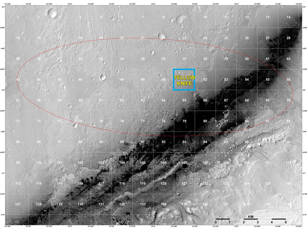
Staking out Curiosity's Landing Site The geological context for the landing site of NASA's Curiosity rover is visible in this image mosaic obtained by the High-Resolution Imaging Science Experiment (HiRISE) camera on NASA's Mars Reconnaissance Orbiter. The area around the landing site has been divided into square areas of interest about .9-mile (1.5-kilometers) wide. The mission has divided the surface into those quadrangles, or quads, so that groups of team members can focus their analysis on a particular part of the surface. Mt. Sharp is to the bottom right, out of the picture. HiRISE is one of six instruments on NASA's Mars Reconnaissance Orbiter. The University of Arizona, Tucson, operates the orbiter's HiRISE camera, which was built by Ball Aerospace & Technologies Corp., Boulder, Colo. NASA's Jet Propulsion Laboratory, a division of the California Institute of Technology in Pasadena, manages the Mars Reconnaissance Orbiter Project for the NASA Science Mission Directorate, Washington. Lockheed Martin Space Systems, Denver, built the spacecraft. Image Credit: NASA/JPL-Caltech/Univ. of Arizona |
| 日付 | |
| 原典 | http://mars.jpl.nasa.gov/msl/images/pia16031_Sumner_2MSL_Quadmapping_yellowknife-br2.jpg |
| 作者 | NASA/JPL-Caltech/Univ. of Arizona |
ライセンス
| このファイルはアメリカ航空宇宙局(NASA)によって作成されたものです。NASAの著作権の方針では、特記事項が無い場合、NASAの資料はパブリックドメインとなります。 (詳しくはTemplate:PD-USGov、NASAの著作権の方針について(英語)又はジェット推進研究所(JPL)の画像使用に関するガイドライン(英語)をご覧ください。) |
||
 |
注意事項:
|
ファイルの履歴
過去の版のファイルを表示するには、その版の日時をクリックしてください。
| 日付と時刻 | サムネイル | 寸法 | 利用者 | コメント | |
|---|---|---|---|---|---|
| 現在の版 | 2012年8月15日 (水) 18:30 | | 1,024 × 768 (173キロバイト) | Drbogdan |
ファイルの使用状況
以下のページがこのファイルを使用しています:
グローバルなファイル使用状況
以下に挙げる他のウィキがこの画像を使っています:
- bg.wikipedia.org での使用状況
- bn.wikipedia.org での使用状況
- ca.wikipedia.org での使用状況
- en.wikipedia.org での使用状況
- es.wikipedia.org での使用状況
- fa.wikipedia.org での使用状況
- it.wikipedia.org での使用状況
- ko.wikipedia.org での使用状況
- test.wikipedia.org での使用状況
- tr.wikipedia.org での使用状況
- uk.wikipedia.org での使用状況
- zh.wikipedia.org での使用状況