
ファイル:Marion Island, South Africa, EO-1 ALI satellite image, 5 May 2009.jpg

元のファイル (3,058 × 2,222 ピクセル、ファイルサイズ: 1.85メガバイト、MIME タイプ: image/jpeg)
ウィキメディア・コモンズのファイルページにある説明を、以下に表示します。
|
概要
| 解説 |
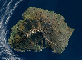
English: Satellite image of South Africa's Marion Island.
Original NASA caption, for a version similarly cropped to show just Marion Island: "A dusting of ice graced the summit of Marion Island in early May 2009 as waves breaking against the island’s shore formed a broken perimeter of white. Like its smaller neighbor, Prince Edward Island, Marion Island is volcanic, rising above the waves of the Indian Ocean off the southern coast of Africa. Prince Edward and Marion are part of South Africa’s Western Cape Province. (Both islands appear in the large image.) "The Advanced Land Imager (ALI) on NASA’s Earth Observing-1 (EO-1) satellite acquired this natural-color image on May 5, 2009. Sunlight illuminates the northern slopes of the volcanic island, leaving southern slopes in shadow. More than 100 small, reddish volcanic cones dot the island, some of the most conspicuous in the north and east. The island reaches its highest elevation, 1,230 meters (4,040 feet), near the center. Vegetation is generally sparse on Marion Island. Lichens live near the summit, and mosses and ferns grow elsewhere on the boggy surface, but trees don’t grow on the island. "Occurring at the juncture between the African Continental Plate and the Antarctic Plate, Marion Island has been volcanically active for 18,000 years. The first historical eruption was recorded in November 1980 when researchers recorded two new volcanic hills and three lava flows. Researchers observed another small eruption in 2004. "Besides volcanic cones, Marion Island is home to Marion Base, part of the South African National Antarctic Programme. Focusing on biological, environmental, and meteorological research, the base is situated on the island’s northeastern coast." |
| 日付 | |
| 原典 | Image (here cropped) and description (of their similar cropped version) |
| 作者 | NASA Earth Observatory image created by Jesse Allen, using EO-1 ALI data provided courtesy of the NASA EO-1 team and the United States Geological Survey. Caption by Michon Scott. |
| その他のバージョン |
|

ライセンス
| このファイルはアメリカ航空宇宙局(NASA)によって作成されたものです。NASAの著作権の方針では、特記事項が無い場合、NASAの資料はパブリックドメインとなります。 (詳しくはTemplate:PD-USGov、NASAの著作権の方針について(英語)又はジェット推進研究所(JPL)の画像使用に関するガイドライン(英語)をご覧ください。) |
||
 |
注意事項:
|
ファイルの履歴
過去の版のファイルを表示するには、その版の日時をクリックしてください。
| 日付と時刻 | サムネイル | 寸法 | 利用者 | コメント | |
|---|---|---|---|---|---|
| 現在の版 | 2011年4月5日 (火) 09:24 | | 3,058 × 2,222 (1.85メガバイト) | Avenue | {{Information |Description ={{en|1=Satellite image of South Africa's Marion Island. Original NASA caption, for a version similarly cropped to show just Marion Island: "A dusting of ice graced the summit of Marion Island in early May 2009 as waves bre |
ファイルの使用状況
以下のページがこのファイルを使用しています:
グローバルなファイル使用状況
以下に挙げる他のウィキがこの画像を使っています:
- af.wikipedia.org での使用状況
- ast.wikipedia.org での使用状況
- be.wikipedia.org での使用状況
- br.wikipedia.org での使用状況
- ceb.wikipedia.org での使用状況
- cs.wikipedia.org での使用状況
- da.wikipedia.org での使用状況
- de.wikipedia.org での使用状況
- el.wikipedia.org での使用状況
- en.wikipedia.org での使用状況
- fr.wikipedia.org での使用状況
- fr.wikivoyage.org での使用状況
- he.wikipedia.org での使用状況
- hu.wikipedia.org での使用状況
- lv.wikipedia.org での使用状況
- nn.wikipedia.org での使用状況
- pl.wikipedia.org での使用状況
- www.wikidata.org での使用状況
- zh.wikipedia.org での使用状況