
ファイル:Martis Creek Lake and Dam winter.jpg

このプレビューのサイズ: 800 × 527 ピクセル。 その他の解像度: 320 × 211 ピクセル | 640 × 422 ピクセル | 1,024 × 674 ピクセル | 1,500 × 988 ピクセル。
元のファイル (1,500 × 988 ピクセル、ファイルサイズ: 743キロバイト、MIME タイプ: image/jpeg)
ウィキメディア・コモンズのファイルページにある説明を、以下に表示します。
|
| 解説 |
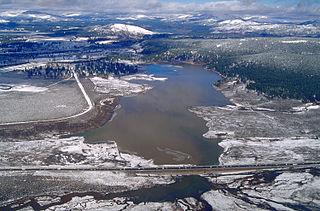
English: Aerial view of Martis Creek Lake and Dam in Nevada and Placer Counties, California, USA. The dam is located in Nevada County, approximately 5.5 miles (9 km) east of Truckee. The lake, when full, extends south along Martis Creek into Placer County. The lake lies next to the Truckee-Tahoe Airport, whose runway can be seen at far left in the picture. This photograph appears to have been taken in the winter when the water level was high. California State Route 267, also known as North Shore Road, runs across the picture at bottom. Boca Reservoir is visible at the top of the picture in the distance. View is to the north.
Coordinates: 39°19′16.86″N 120°6′46.53″W / 39.32135°N 120.112925°W |
|||
| 場所 | Nevada County, California, USA | |||
| 日付 | not specified or unknown | |||
| 原典 |
U.S. Army Corps of Engineers Digital Visual Library Image page Image description page Digital Visual Library home page |
|||
| 作者 | Michael Nevins, U.S. Army Corps of Engineers | |||
| 許可 (ファイルの再利用) |
|
ファイルの履歴
過去の版のファイルを表示するには、その版の日時をクリックしてください。
| 日付と時刻 | サムネイル | 寸法 | 利用者 | コメント | |
|---|---|---|---|---|---|
| 現在の版 | 2007年5月5日 (土) 17:02 | | 1,500 × 988 (743キロバイト) | DanMS | {{Information | Description = {{en|Aerial view of Martis Creek Lake and Dam in Nevada and Placer Counties, California, USA. The dam is located in Nevada County, approximately 5.5 miles (9 km) east of Truckee. The lake, when full, extends south along Ma |
ファイルの使用状況
以下のページがこのファイルを使用しています:
グローバルなファイル使用状況
以下に挙げる他のウィキがこの画像を使っています:
- en.wikipedia.org での使用状況
- es.wikipedia.org での使用状況
- fr.wikipedia.org での使用状況
- pam.wikipedia.org での使用状況
- vi.wikipedia.org での使用状況