
ファイル:NASA RabaulVolcano PIA01767.jpg

このプレビューのサイズ: 515 × 600 ピクセル。 その他の解像度: 206 × 240 ピクセル | 412 × 480 ピクセル | 853 × 993 ピクセル。
元のファイル (853 × 993 ピクセル、ファイルサイズ: 855キロバイト、MIME タイプ: image/jpeg)
ウィキメディア・コモンズのファイルページにある説明を、以下に表示します。
|
概要
| 解説 |
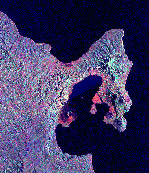
English: Space Radar Image of Rabaul Volcano, New Guinea
Credit NASA JPL http://visibleearth.nasa.gov/view_rec.php?id=434 This is a radar image of the Rabaul volcano on the island of New Britain, Papua New Guinea taken almost a month after its September 19, 1994, eruption that killed five people and covered the town of Rabaul and nearby villages with up to 75 centimeters (30 inches) of ash. More than 53,000 people have been displaced by the eruption. The image was acquired by the Spaceborne Imaging Radar-C/X-band Synthetic Aperture Radar (SIR-C/X-SAR) aboard the space shuttle Endeavour on its 173rd orbit on October 11, 1994. This image is centered at 4.2 degrees south latitude and 152.2 degrees east longitude in the southwest Pacific Ocean. The area shown is approximately 21 kilometers by 25 kilometers (13 miles by 15.5 miles). North is toward the upper right. The colors in this image were obtained using the following radar channels: red represents the L-band (horizontally transmitted and received); green represents the L-band (horizontally transmitted and vertically received); blue represents the C-band (horizontally transmitted and vertically received). |
|||||
| 原典 | http://visibleearth.nasa.gov/view_rec.php?id=434 | |||||
| 作者 | NASA/JPL | |||||
| 許可 (ファイルの再利用) |
|

| このタグは、添付された著作物の著作権状況を示すものではありません。通常の著作権タグも必要です。Commons:ライセンシングもご覧ください。 他言語での翻訳:
|
元のアップロードログ
元のファイルページはこちら。以下の利用者は全てen.wikipediaに属します。
- 2005-05-17 12:15 SeanMack 853×993× (875239 bytes) {{PD-USGov-NASA}} Space Radar Image of Rabaul Volcano, New Guinea Credit NASA JPL http://visibleearth.nasa.gov/view_rec.php?id=434 This is a radar image of the Rabaul volcano on the island of New Britain, Papua New Guinea taken almost a month after
ファイルの履歴
過去の版のファイルを表示するには、その版の日時をクリックしてください。
| 日付と時刻 | サムネイル | 寸法 | 利用者 | コメント | |
|---|---|---|---|---|---|
| 現在の版 | 2009年5月1日 (金) 13:17 | | 853 × 993 (855キロバイト) | File Upload Bot (Magnus Manske) | {{BotMoveToCommons|en.wikipedia|year={{subst:CURRENTYEAR}}|month={{subst:CURRENTMONTHNAME}}|day={{subst:CURRENTDAY}}}} {{Information |Description={{en|Space Radar Image of Rabaul Volcano, New Guinea Credit NASA JPL http://visibleearth.nasa.gov/view_re |
ファイルの使用状況
以下のページがこのファイルを使用しています:
グローバルなファイル使用状況
以下に挙げる他のウィキがこの画像を使っています:
- br.wikipedia.org での使用状況
- en.wikipedia.org での使用状況
- fa.wikipedia.org での使用状況
- fr.wikipedia.org での使用状況
- hu.wikipedia.org での使用状況
- id.wikipedia.org での使用状況
- it.wikipedia.org での使用状況
- ko.wikipedia.org での使用状況
- nl.wikipedia.org での使用状況
- ru.wikipedia.org での使用状況
- uk.wikipedia.org での使用状況
- zh.wikipedia.org での使用状況