
ファイル:Operation Azul.jpg
このプレビューのサイズ: 800 × 465 ピクセル。 その他の解像度: 320 × 186 ピクセル | 640 × 372 ピクセル | 1,024 × 595 ピクセル | 1,280 × 744 ピクセル | 2,040 × 1,185 ピクセル。
元のファイル (2,040 × 1,185 ピクセル、ファイルサイズ: 449キロバイト、MIME タイプ: image/jpeg)
ウィキメディア・コモンズのファイルページにある説明を、以下に表示します。
|
概要
Drawn by myself (Max Smith) in Visio.
Re-uploaded as JPG - big PNGs don't seem to work.
Released into the public domain, but a credit would be nice.
Based on a map in Martin Middlebrook's : The Fight For The Malvinas.
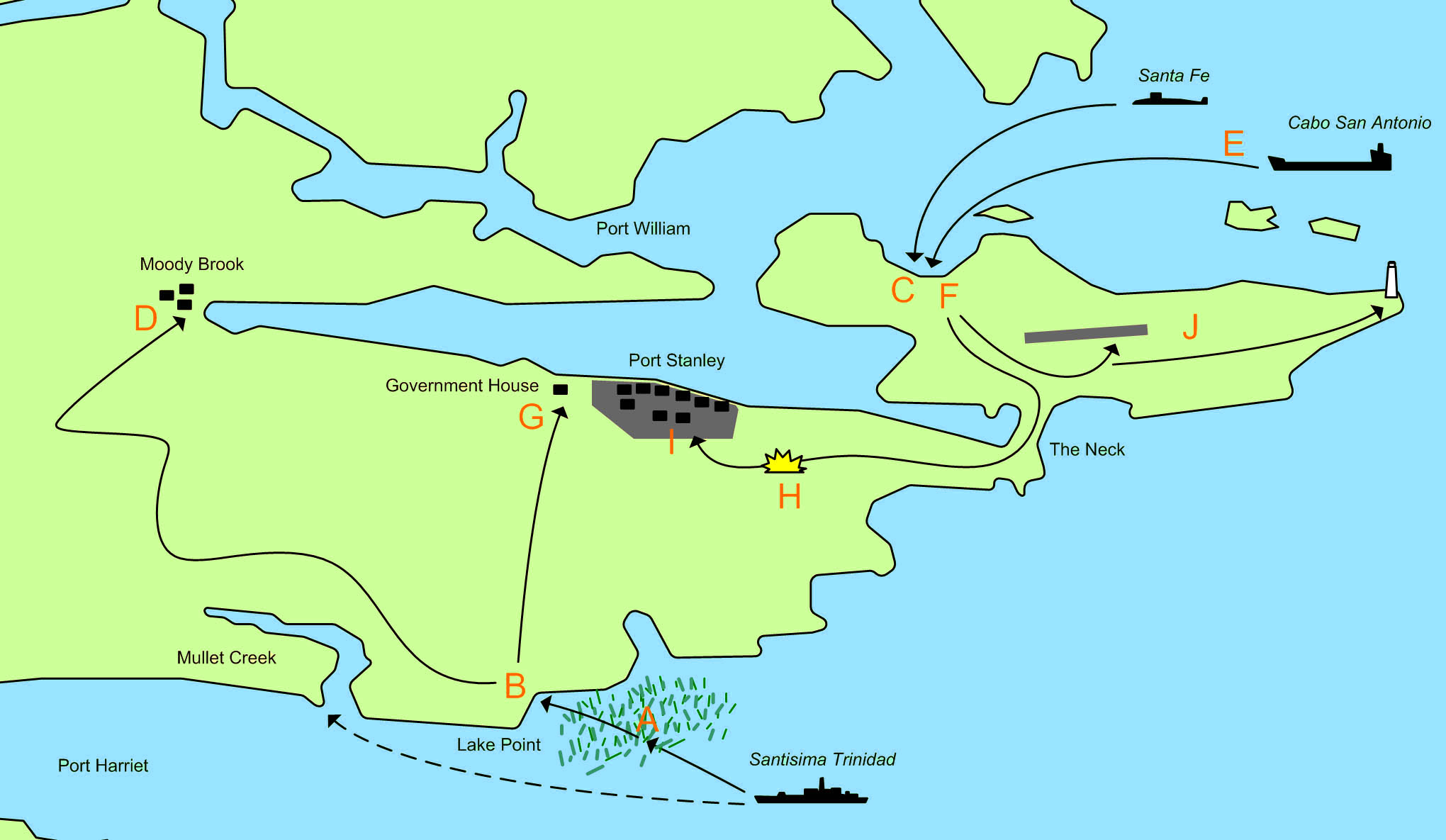
The map showing the area of the Falkland Islands around Port Stanley and the actions of 1 April 1982 and 2 April 1982 during the 1982 Invasion of the Falkland Islands.

|
このファイルのベクター画像 (SVG) が利用できます。 使う目的に対し、元画像よりもSVGがより優れている場合、SVG画像を使用して下さい。
File:Operation Azul.jpg → File:Operation Azul.svg
|
 |
- A. 21:30 1 April - The Type 42 destroyerSantisima Trinidad begins loading marines of the Amphibious Commando Company into 21 small inflatable motor boats. These set out for Mullet Creek at but sail too far north and are caught up in beds of Kelp, which cause problems for the boats. They decide to head for the nearest beach, which is near Lake Point.
- B. 23:00 1 April - The first group of 91 men lands on an unamed beach at Lake Point. The group splits into a smaller force commanded by Lieutenant-Commander Giachino who head towards Government House, and a larger force commanded by Lieutenant-Commander Sabarots who head towards Moody Brook Barracks.
- C. 04:30 2 April - A small advanced group from Buzos Tacticos is landed from the Submarine Santa Fe.
- D. 05:30 2 April - Lieutenant-Commander Sabarots force reaches and surrounds the Barracks. They throw tear gas grenades into the buildings and fire machine gun tracer over the buildings. They find the buildings are deserted.
- E. 06:00 2 April - 20 FMC Amtracs and several LARC 5 stores carrying vehicles are launched from Caba San Antionio. The force splits into 3 groups:
- A four Amtrac vanguard. Including one carrying the Army Platoon.
- The main force of 14 Amtracs.
- The second in command, a recovery Amtrac and LARC vehciles.
- F. 06:30 2 April - The first Amtracs land and meet no resistance. The Army platoon captures the deserted airport.
- G. 06:30 2 April - The 5 man Argentine force reaches government house, where they are stopped by 31 Royal Marines, 11 armed Royal Navy men and 1 locals. Two Argentines are wounded (one would later die), and the remaining 3 are captured.
- H. 07:15 2 April - Having met no resistance, the Argentine Amtracs advance on Stanley, when they are ambushed from a house about 500 meters from the road. Royal Marines use rockets and machine gun fire. The Royal Marines fall back to government house. One of the Amtracs is scarred by machine gun fire, and there is one minor injury.
- I. 08:00 2 April - The Argentine Amtrac force secures Port Stanley.
- J. The Army platoon begins clearing the runway and seizes the light house.
ライセンス
| この著作物の著作権者である私は、この著作物における権利を放棄しパブリックドメインとします。これは全世界で適用されます。 一部の国では、これが法的に可能ではない場合があります。その場合は、次のように宣言します。 私は、あらゆる人に対して、法により必要とされている条件を除き、如何なる条件も課すことなく、あらゆる目的のためにこの著作物を使用する権利を与えます。 |
ファイルの履歴
過去の版のファイルを表示するには、その版の日時をクリックしてください。
| 日付と時刻 | サムネイル | 寸法 | 利用者 | コメント | |
|---|---|---|---|---|---|
| 現在の版 | 2011年3月10日 (木) 22:27 | | 2,040 × 1,185 (449キロバイト) | Megapixie | Fix colors. |
| 2006年11月26日 (日) 11:54 |  | 2,040 × 1,185 (159キロバイト) | Electionworld | == Summary == Drawn by myself (Max Smith) in Visio. Re-uploaded as JPG - big PNGs don't seem to work. Released into the public domain, but a credit would be ''nice''. Based on a map in Martin Middlebrook's : ''The Fight For The Malvinas''. The map sho |
ファイルの使用状況
以下の 2 ページがこのファイルを使用しています:
グローバルなファイル使用状況
以下に挙げる他のウィキがこの画像を使っています:
- ar.wikipedia.org での使用状況
- ceb.wikipedia.org での使用状況
- en.wikipedia.org での使用状況
- es.wikipedia.org での使用状況
- fi.wikipedia.org での使用状況
- fr.wikipedia.org での使用状況
- he.wikipedia.org での使用状況
- hu.wikipedia.org での使用状況
- no.wikipedia.org での使用状況
- pl.wikipedia.org での使用状況
- ru.wikipedia.org での使用状況
- sl.wikipedia.org での使用状況
- www.wikidata.org での使用状況