
ファイル:Txu-oclc-6595921-nc30-15 crop southwest.jpg

このプレビューのサイズ: 800 × 427 ピクセル。 その他の解像度: 320 × 171 ピクセル | 640 × 341 ピクセル | 1,341 × 715 ピクセル。
元のファイル (1,341 × 715 ピクセル、ファイルサイズ: 1.36メガバイト、MIME タイプ: image/jpeg)
ウィキメディア・コモンズのファイルページにある説明を、以下に表示します。
|
| 解説 |
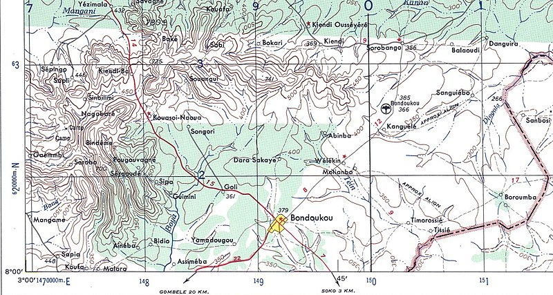
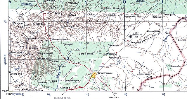
English: US Army map of West Africa, specifically the area along northern border of modern Ghana and Cote d'Ivoire (then Gold Coast Colony and French West Africa). |
| 日付 | |
| 原典 | |
| 作者 |
|
この画像には画像編集が施されています。原本に対して次のデジタル的な変更が行われました。
|
|
|
 |
元のアップロードログ
This image is a derivative work of the following images:
- Image:Txu-oclc-6595921-nc30-15.jpg licensed with PD-USGov-Military-Army
- 2008-09-13T01:15:15Z T L Miles 5000x3785 (5264461 Bytes) {{Information |Description={{en|1=US Army map of West Africa, specifically the area along northern border of modern Ghana and Cote d'Ivoire (then Gold Coast Colony and French West Africa).}} |Source=http://www.lib.utexas.edu/
Uploaded with derivativeFX
ファイルの履歴
過去の版のファイルを表示するには、その版の日時をクリックしてください。
| 日付と時刻 | サムネイル | 寸法 | 利用者 | コメント | |
|---|---|---|---|---|---|
| 現在の版 | 2008年9月13日 (土) 01:22 | | 1,341 × 715 (1.36メガバイト) | T L Miles | {{Information |Description={{en|1=US Army map of West Africa, specifically the area along northern border of modern Ghana and Cote d'Ivoire (then Gold Coast Colony and French West Africa).}} |Source=*Image:Txu-oclc-6595921-nc30-15.jpg |Date=2008-09- |
ファイルの使用状況
以下のページがこのファイルを使用しています:
グローバルなファイル使用状況
以下に挙げる他のウィキがこの画像を使っています: